Sutton Brook flows throughout Sutton and ultimately into the St Helens / Sankey Canal. The brook has been in existence for hundreds of years and has attained notoriety on many occasions. During the nineteenth century, it was colloquially referred to as the 'Stygian' brook (i.e. dark and dismal) and in more recent times it was known to St.Helens folk as 'Stinky' brook. For many years the brook was the dumping ground for much industrial and chemical waste which gave rise to the odour.

The Sutton Brook Greenway sign in Watery Lane in Sutton photographed in 2008
The Sutton Brook Greenway sign in Watery Lane pictured in 2008
Greenway sign in Watery Lane
flow through our midst and which for miles are perfect pests and horrible stinking cesspools.
Sutton Brook was particularly a pest to those who lived in the Watery Lane area, who for many decades also had to endure persistent flooding. Ironically part of the brook further south was dug as a relief channel early in the twentieth century to help prevent Sutton Manor Colliery from flooding.

The Pendlebury / Sutton Brook about to pass under Clock Face Road and then into Sutton Mill Dam
The Pendlebury / Sutton Brook about to pass under Clock Face Road
About to pass under Clock Face Road
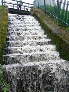
The exact point of delineation between Pendlebury Brook and Sutton Brook is a matter for debate. However the stream is certainly Sutton Brook when it passes into the Sutton Mill Dam Wildlife Park where it forms a lake behind the dam measuring about 360 metres in length. Leaving Sutton Mill Dam as a stepped waterfall (pictured left), Sutton Brook flows adjacent to the Wheatsheaf pub and then under Mill Lane.
For many years it was referred to at this point as 'Dickies Bruk', named after local farmer Dickie Rimmer. Nearby land used to be quite boggy but in the 1950s, St.Helens Corporation deepened the brook and tipped refuse and earth onto the ground near the Wheatsheaf to ameliorate the problem.
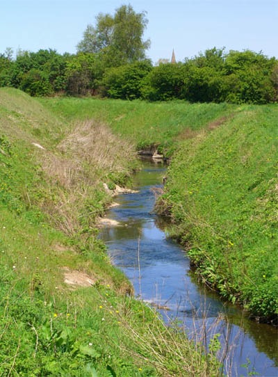
The stream continues its journey under the Liverpool to Manchester railway line and into the former Whalley's Dam, which was also known as Glass House Dam. It used to be quite deep here but is now just a shallow, running brook. From here it flows under Victoria Bridge in Gerards Lane into the Monastery Dam, previously known as Waterdale Dam and sometimes called St.Anne's reservoir.

A grey heron flies over Monastery Dam by Gerards Lane which used to be used by Sutton Glassworks
A grey heron flies over Monastery Dam by Gerards Lane
A grey heron flies over Monastery Dam

Sutton Brook leaves Monastery Dam as a waterfall before flowing under Robins Lane and Ellamsbridge Road
The brook leaves Monastery Dam as a waterfall then flows under Robins Lane
Sutton Brook leaves Monastery Dam
The present-day direct route from Ellamsbridge means it traverses under Watery Lane to behind Berrys Lane. It turns from flowing north to flowing east before turning north again in the area of Jackson Street and Parr Industrial Estate, where it is joined by the Hardshaw Brook.
At the point where the Hardshaw Brook joins the Sutton Brook, the water becomes the Sankey Brook. As it flows through Parr and Broad Oak, it's joined by the Rainford Brook and the Black Brook. This area is known as the Sankey Valley and the water flows via the Sankey Canal through Earlestown, Newton, Winwick, Penketh and Great Sankey.
The Sutton Brook Greenway sign in Watery Lane pictured at the top of this page is located close to where this photograph was taken. It describes the wildlife, birds and wildflowers that can be found on the brook's route through the former township as it traverses towards St.Helens town centre. Part of the informative sign reads:
There is a wide range of birds to be seen along its route including blackbirds, chaffinches, sparrows and thrushes. Amongst the banks and waterway you can see kingfishers, moorhens, grey wagtails, coots and mallards. Providing shelter and food for the birds you will find trees such as willow, ash, oak, hazel, cherry, crab apple and elder. Along the route you will find many species of wildflowers including foxglove, yellow loosestrife and red campion. Grasses and herbs are also found and these encourage butterflies and moths. Living in the brook and on its banks are water voles which should not be mistaken for rats. Fish like roach can be found in the brook especially near the outfalls.
A positive side effect of the ‘stinking brook’ has been the advent of a large number of unusual wildflower species. These can be found along the banks of the Sutton Brook and St.Helens Canal and are more commonly found in sand dunes and in limestone areas. This is because lime-rich waste that the Leblanc chemical process created was dumped in the Sutton / Sankey brooks. So as well as the above-named flowers, look out for colourful species like fairy flax, yellow wort and wild mignonette.